The Pacific Northwest offers some of the best motorcycle routes in the United States because it compresses wild coastline, volcanic peaks, rain-soaked forests, high desert, and compact touring towns into one rider-friendly region. For motorcyclists, “Pacific Northwest” usually means Washington, Oregon, and the adjoining riding corridors that connect the Pacific Coast to the Cascade Range. “Route guides” are more than lists of roads; they explain surfaces, weather, fuel stops, seasonal timing, traffic patterns, and what kind of motorcycle each road suits best. After years of planning trips for weekend riders and long-distance tourers, I have found that the best routes here succeed for the same reason: they combine scenery with rhythm. A road can be beautiful, but if pavement quality is inconsistent, corners are blind, or services are scarce, it may not be ideal for most riders.
This hub is designed to help you choose the right Pacific Northwest motorcycle route based on distance, experience, bike type, and travel goals. Some riders want iconic ocean views on Highway 101. Others want technical mountain riding on Washington State Route 20, the North Cascades Highway. Some want a multi-day loop linking Portland, Mount Hood, the Columbia River Gorge, and central Oregon. Each route in this guide answers practical questions directly: When should you go? What hazards matter most? Where does traffic build? What are the standout stops? That matters because the Pacific Northwest is not a one-season destination. Snow closes mountain passes, coastal fog reduces visibility, wildfire smoke changes summer plans, and shoulder seasons can be either magical or miserable depending on preparation.
As a hub page for route guides under The Open Road, this article maps the major ride categories and the flagship roads that define them. You will find coast routes, Cascade crossings, Gorge rides, volcanic byways, and inland connectors, along with examples of how to combine them into day rides and longer tours. If you are researching the best motorcycle routes in the Pacific Northwest, start here, then use the route types and planning notes below to decide which road deserves your next ride.
How to Choose the Right Pacific Northwest Motorcycle Route
The best route depends on how you ride, not just on what looks good in a photo. Coastal routes are ideal for riders who prefer sweepers, frequent towns, seafood stops, and moderate daily mileage. Mountain routes suit riders who want elevation changes, sharper corner sequences, and dramatic scenery, but they require tighter timing because of snowpack and early nightfall in spring and fall. Gorge and river routes often balance both, offering reliable pavement, steady curves, and more predictable services.
Bike type matters. Large touring motorcycles and sport-tourers shine on US 101, the Columbia River Highway corridors, and Mount Hood loops because fuel, lodging, and road width are consistent. Adventure bikes expand your options on forest connectors and mixed-surface scenic detours, especially around central Oregon and the east side of the Cascades. Cruisers do well almost everywhere here, but riders should pay close attention to frost heaves, tar snakes in summer heat, and rough pavement on lesser-maintained backroads. Sportbike riders will love roads like OR 242, the McKenzie Pass Highway, but must watch for cyclists, decreasing-radius turns, and heavy tourist traffic during peak summer weekends.
Distance planning should also be realistic. In the Pacific Northwest, 220 scenic miles can take longer than 350 interstate miles because of photo stops, weather changes, construction zones, and slower recreational traffic. A smart route guide should always factor in pace, not just mileage.
Best Coastal Motorcycle Routes: Highway 101 and Beyond
If one road defines Pacific Northwest motorcycle touring, it is US 101. On the Oregon Coast, it delivers sea stacks, cliffside viewpoints, fishing towns, and rolling sections that are accessible to nearly any competent rider. The best Oregon segments for motorcycles are often the stretches between Astoria and Cannon Beach, Newport and Florence, and Bandon to Brookings. These sections mix broad ocean views with enough corner variety to stay engaging without becoming exhausting. Popular stops include Ecola State Park near Cannon Beach, Yaquina Head near Newport, Heceta Head Lighthouse, and Samuel H. Boardman State Scenic Corridor on the south coast.
Washington’s coastal riding is less continuous but still memorable, especially when paired with the Olympic Peninsula loop. Riders often combine US 101 around Lake Crescent, Forks, and Aberdeen with side trips to Rialto Beach, La Push, or Hurricane Ridge when open. The Olympic loop is excellent for riders who want a full-day or two-day tour with varied scenery rather than nonstop technical riding. Road conditions are usually good, though rain, logging trucks, and summer RV traffic demand patience.
Coastal riding has specific strengths and limitations. Temperatures are moderate even in midsummer, making the coast a dependable choice when inland valleys are hot. Fog is common in the morning, crosswinds can be strong on exposed headlands, and tourist congestion peaks from late June through early September. In my experience, the best way to ride the coast is to start early, stop often, and keep daily goals modest. The reward is less about speed and more about steady motion through one scenic landmark after another.
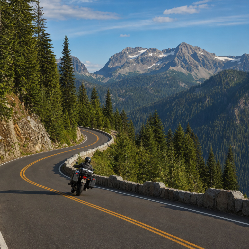
Best Cascade Mountain Routes for Riders Who Want Elevation and Curves
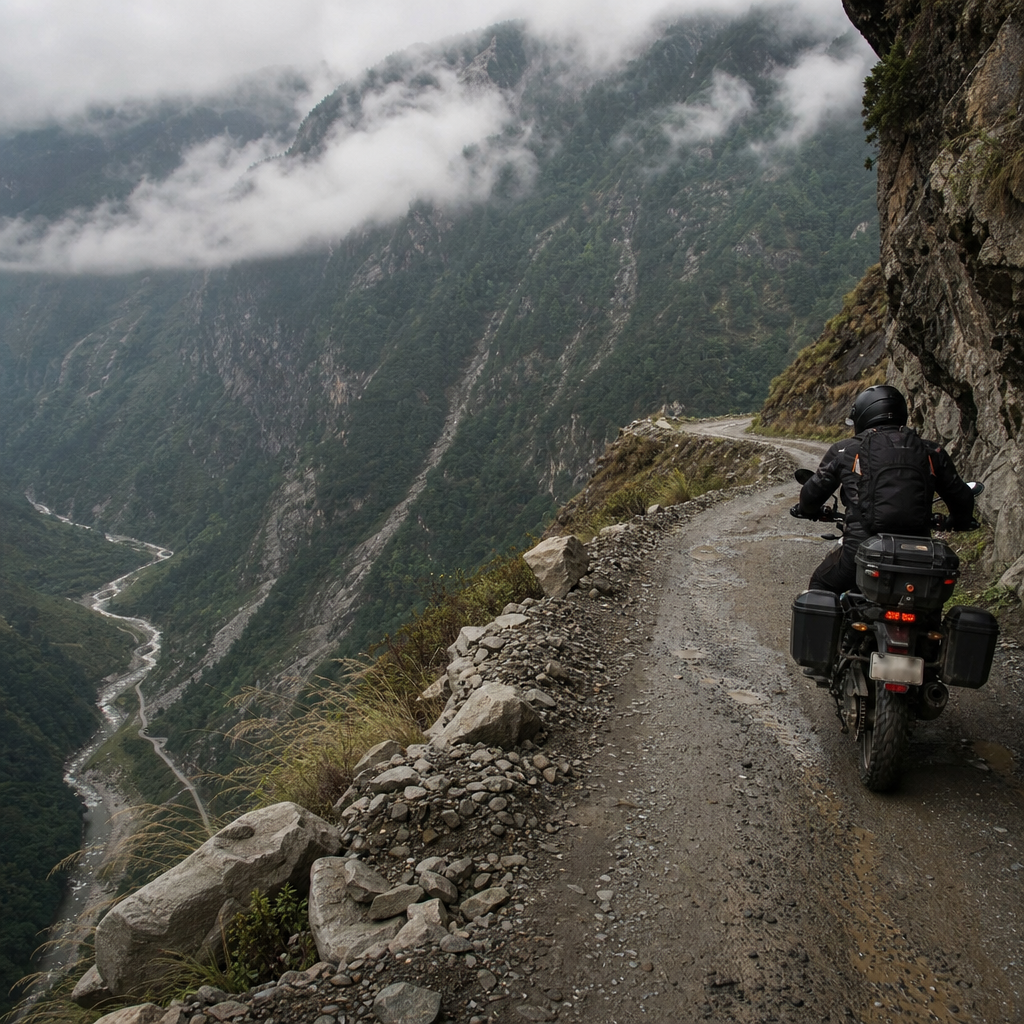
The Cascade routes are where many riders find the region’s most memorable pavement. Washington State Route 20, the North Cascades Highway, is one of the premier motorcycle roads in America. Running between Sedro-Woolley and Winthrop, it cuts through North Cascades National Park terrain with long sweepers, alpine views, and high-elevation drama around Washington Pass and Rainy Pass. It usually opens sometime in spring after intensive snow removal, often later than lower routes. Riders should verify conditions with the Washington State Department of Transportation before departure because openings vary widely by snow year.
In Oregon, the McKenzie Pass Highway, OR 242, is shorter but more technical. This historic road crosses lava fields west of Sisters and includes narrow lanes, tight turns, and striking views near Dee Wright Observatory. It is a favorite among experienced riders precisely because it feels intimate and old-school, but larger bikes need care because the road is tighter than many expect. Another standout is the Mount Hood area, especially loops that use OR 35, US 26, and OR 216 or connect to Hood River through the orchard country near Parkdale. These roads combine volcanic scenery with smoother, more forgiving cornering than the tightest passes.
Cascade routes are best from late spring through early fall, but exact timing changes by elevation. Snow, gravel in corners, and freeze-thaw damage are common early-season issues. Afternoon thunderstorms can reduce traction quickly. For riders who want peak scenery and cleaner pavement, late July through September is usually the sweet spot, though wildfire smoke can become the deciding factor in recent years.
Columbia River Gorge and Volcanic Scenic Byways
The Columbia River Gorge is one of the most versatile motorcycle touring zones in the Pacific Northwest because it works as a day ride, a weekend loop, or a connector between larger tours. On the Oregon side, sections of the Historic Columbia River Highway offer classic viewpoints and engineering landmarks, including Vista House at Crown Point and waterfalls such as Multnomah Falls, Horsetail Falls, and Latourell Falls. On the Washington side, State Route 14 tends to move better for motorcycles, with sweeping river views and easier through-travel. Linking both sides by bridge creates an excellent loop from Portland or Hood River.
For riders who want bigger landscapes, Oregon’s volcanic byways add depth to a route guide strategy. Crater Lake National Park is the headline destination, with Rim Drive delivering extraordinary views of the deepest lake in the United States. Access roads from Roseburg, Medford, or Bend can be woven into multi-day rides, though snow can linger well into early summer. Mount St. Helens in Washington is another classic objective, especially the ride to Johnston Ridge area access when available, where the 1980 eruption becomes a visible part of the route rather than just a historical fact. These roads reward riders who appreciate geology as much as curves.
The Gorge and volcanic routes matter because they turn a scenic ride into a structured tour. You are not simply chasing corners; you are moving through landscapes shaped by floods, eruptions, glaciation, and river trade. That historical and geological context makes these roads more memorable and easier to build into themed trips.
Route Planning Essentials: Season, Safety, and Services
Good Pacific Northwest route planning starts with timing. Coastal rides are most reliable from May through October, though they are rideable year-round with proper waterproof gear and caution. High Cascade routes are generally summer roads. Shoulder-season travelers should always check state DOT pass reports, park alerts, and fire activity maps. In Washington, mountain weather can change within an hour. In Oregon, smoke and roadwork often influence route quality as much as rainfall.
Fuel strategy matters more than many first-time visitors expect. Major corridors have regular stations, but some mountain towns close early, and remote stretches east of the Cascades can create uncomfortable gaps for smaller tanks. I advise riders to refuel when they hit half a tank on unfamiliar roads, especially on weekends when detours may add distance. Cell coverage is inconsistent in mountain and forest zones, so offline maps through Garmin, REVER, Calimoto, or Google Maps downloaded in advance are worth using. Paper maps still help when smoke, closures, or low batteries force changes.
Wildlife and road hazards are part of the region. Deer are common at dawn and dusk, elk appear on some coastal and inland stretches, and shaded corners can hold moisture or moss even on otherwise dry days. Logging trucks deserve special respect; they are fast, large, and frequently encountered on working roads. The safest pace is one that preserves sightlines and leaves margin for surprises.
Recommended Pacific Northwest Motorcycle Routes at a Glance
This comparison helps riders match road type to travel style, bike setup, and seasonal window.
| Route | Best For | Ideal Season | Key Stops | Main Cautions |
|---|---|---|---|---|
| US 101 Oregon Coast | Scenic touring, two-day coastal trips | May to October | Cannon Beach, Newport, Florence, Bandon, Brookings | Fog, RV traffic, crosswinds |
| Olympic Peninsula Loop | Varied scenery, relaxed touring | Late spring to early fall | Port Angeles, Lake Crescent, Forks, beaches | Rain, long distances between major attractions |
| North Cascades Highway | Mountain scenery, sweeping curves | Summer to early fall | Diablo Lake, Washington Pass, Winthrop | Seasonal closure, rockfall, limited services |
| McKenzie Pass OR 242 | Technical riding, volcanic terrain | Mid-summer to early fall | Sisters, Dee Wright Observatory, McKenzie River area | Tight turns, cyclists, seasonal closure |
| Columbia Gorge Loop | Day rides from Portland, easy touring | Spring through fall | Vista House, Hood River, waterfalls, SR 14 viewpoints | Tourist congestion, wind |
| Crater Lake Access and Rim | Bucket-list scenery, multi-day tours | Summer to early fall | Rim Drive, lodge area, central Oregon connectors | Snow, altitude, wildlife |
How to Build a Weekend or Weeklong Tour
For a weekend, keep the route simple and avoid trying to sample every headline road. A strong Oregon plan is Portland to Hood River via the Gorge, south around Mount Hood, overnight in Bend or Government Camp, then return through the Santiam or Columbia corridor depending on conditions. A strong Washington plan is Seattle to the Olympic Peninsula with an overnight in Port Angeles or Forks, returning through the southern loop. These itineraries leave room for weather changes and unplanned stops, which is exactly what the region rewards.
For a weeklong tour, combine route families. One of my favorite structures starts in Portland, heads west to the Oregon Coast, rides south on US 101, cuts inland through the Umpqua or Rogue region toward Crater Lake, continues north through Bend and Sisters, crosses McKenzie Pass if open, then returns through the Columbia River Gorge. A Washington-focused version can link Mount Rainier approaches, the North Cascades Highway, Winthrop, and the Olympic Peninsula. The principle is simple: alternate dense mountain days with easier transit days so fatigue never dulls judgment.
Lodging should be booked early in high season, especially in Hood River, Bend, Winthrop, Port Angeles, and coastal towns on summer weekends. If you prefer flexibility, travel midweek. The roads are calmer, rooms are easier to find, and the riding experience is usually better.
The best motorcycle routes in the Pacific Northwest are not defined by a single road but by the variety packed into a relatively compact region. Riders can watch the Pacific at breakfast, carve through forested sweepers by lunch, and finish the day beneath a volcano or beside a river canyon. That range is what makes this area such a powerful route-guide hub under The Open Road: it gives every type of rider a meaningful starting point. If you want easy scenic touring, choose the coast or the Columbia Gorge. If you want high passes and more demanding cornering, aim for the Cascades. If you want a memorable multi-day ride, combine both and let weather, season, and your motorcycle shape the final plan.
The practical lesson is just as important as the scenery. Check seasonal openings, build routes around fuel and daylight, expect weather to shift, and leave margin for construction, smoke, and traffic. Riders who do that are rewarded with some of the most complete touring experiences in North America. Use this hub to narrow your options, pick the route style that matches your machine and skill level, and then map your next Pacific Northwest ride with confidence.
Frequently Asked Questions
What makes the Pacific Northwest one of the best regions in the U.S. for motorcycle touring?
The Pacific Northwest stands out because it packs an unusual amount of riding variety into a relatively compact region. In a single multi-day trip, riders can move from rugged Pacific shoreline to dense evergreen forest, then climb into the Cascade Range and finish the day in dry, open high desert. Few parts of the country offer that kind of dramatic geographic contrast without requiring massive transit days. Washington and Oregon, in particular, are ideal for route planning because the roads naturally connect scenic coastlines, mountain passes, river valleys, and small touring towns that are well suited to fuel stops, meals, and overnight stays.
Another reason the region is so highly regarded is road character. Many Pacific Northwest motorcycle routes combine sweeping curves, elevation changes, long scenic sightlines, and well-maintained pavement. Riders can choose iconic stretches like the Pacific Coast, forest roads near Mount Hood or Mount Rainier, or crossing routes over the Cascades that feel completely different depending on the season and weather. The experience is not just about twisties for sport riders or scenery for tourers; it is the combination of both. You get roads that are engaging to ride and landscapes that constantly change, which keeps even longer trips feeling fresh.
The region also rewards thoughtful route building. Good Pacific Northwest route guides do more than tell riders where to go. They help explain road surface quality, likely weather swings, fuel availability, traffic patterns, and seasonal closures. That matters here because conditions can change fast, especially when crossing between the coast and higher elevations. A well-planned itinerary helps riders avoid preventable problems and enjoy what the area does best: big scenery, memorable roads, and a strong sense of progression from one environment to the next.
When is the best time of year to ride from the Pacific Coast to the Cascades?
For most riders, the best overall window is late spring through early fall, with July through September offering the most predictable conditions. During that period, the higher Cascade routes are usually open, days are long, and the chances of extended rain or mountain snow are lower. That said, “best” depends on the kind of ride you want. Summer delivers the broadest access, but it also brings more tourist traffic to popular coastal towns, national park corridors, and famous scenic byways. If your priority is maximum route availability, midsummer is excellent. If your priority is lighter traffic and cooler temperatures, early June and September are often sweet spots.
Weather is the key planning factor in the Pacific Northwest. The coast can be cool, damp, and foggy even in summer, while inland valleys may be warm and dry on the same day. Cascade passes can feel significantly colder than lower elevations, especially in the morning and near sunset. In spring and fall, riders should be prepared for sudden rain, wet pavement under tree cover, and occasional debris left behind by storms. Even when the forecast looks mild, mountain microclimates can create very different conditions just a few hours apart.
Seasonal timing matters because some of the region’s best roads are elevation dependent. High routes may open later than expected after heavy snow years, and shoulder-season conditions can include lingering gravel, frost damage, or temporary maintenance work. Before setting out, it is smart to check state transportation updates, wildfire reports in late summer, and local forecasts for both the coast and mountain sections of your route. The best riding days in the Pacific Northwest usually go to riders who plan for changing conditions rather than assuming one forecast covers the whole trip.
Which types of routes are best for riders who want to experience both the coastline and the mountains?
The best coast-to-Cascades routes are usually those that connect a scenic shoreline corridor with an inland river valley or mountain pass, allowing riders to experience a clear transition in landscape over one or two days. In Oregon, many riders start on U.S. 101 for ocean views, sea stacks, and coastal towns, then turn inland through routes that pass farmland, forest, and eventually climb toward the Cascades near areas like Mount Hood or the central Oregon volcano country. In Washington, a similar strategy works well by riding part of the Olympic Peninsula or southern coast first, then heading east toward the mountains through secondary highways and scenic connectors that reduce freeway time.
These hybrid routes are often more rewarding than staying exclusively on the coast or exclusively in the mountains. Coastal roads offer dramatic scenery, but they can be busier and slower in peak season. Mountain routes often provide more technical riding and bigger elevation changes, but they may be less accessible early or late in the season. By combining both, riders get the broadest Pacific Northwest experience: ocean air, dense forest, alpine viewpoints, volcanic terrain, and small inland towns that are perfect for a more relaxed overnight stop.
Route choice should also depend on riding style and trip goals. Riders looking for leisurely touring may prefer a route with more sightseeing stops, lighthouses, overlooks, and walkable towns. Riders prioritizing road dynamics may want inland connectors with more curves, fewer congestion points, and a stronger emphasis on elevation gain. The best guides explain not just where a road goes, but how it feels to ride it, how remote it becomes, whether fuel is sparse, and whether weather exposure increases as you climb. That kind of detail helps riders build an itinerary that matches their bike, pace, and comfort level.
What should riders know about fuel, road conditions, and trip planning on Pacific Northwest motorcycle routes?
Fuel planning is more important than many first-time visitors expect. While western Washington and western Oregon have plenty of services near major towns, some inland and mountain stretches can leave longer gaps between stations, especially if you choose scenic detours, forest corridors, or smaller east-west connectors over the Cascades. It is wise to top off before entering remote sections rather than waiting until the tank gets low. Riders on smaller bikes or those traveling early or late in the day should be especially cautious, since some rural stations may keep limited hours compared with what you would expect in larger population centers.
Road conditions vary widely, which is part of the appeal but also part of the challenge. Along the coast, moisture, wind, and heavy tourist traffic can affect pace and visibility. In forested areas, riders should watch for damp pavement, shaded corners, fallen branches, and patches of moss or debris after storms. In the mountains, frost-heaved pavement, winter sand, rockfall, and roadwork can all show up depending on the season. Summer and early fall can also bring wildfire smoke, which affects visibility and rider comfort even when roads remain open. Good route planning means checking not just the map, but also current transportation alerts and local reports.
It also helps to build your days conservatively. Distances on the map can look modest, but Pacific Northwest riding often takes longer than expected because the roads are scenic, curvy, and full of worthwhile stops. Add in weather changes, ferry schedules in some areas, road construction, and photo breaks, and a day can fill up quickly. The smartest approach is to leave extra margin in your itinerary, carry layers for temperature swings, and think in terms of ride quality rather than maximum mileage. That mindset leads to safer travel and a much better experience overall.
How can riders choose the right Pacific Northwest route for their skill level, motorcycle type, and travel style?
The right route starts with an honest assessment of how you like to ride. If you are on a fully loaded touring bike and prefer smooth, scenic days with frequent stops, you may be happiest on established highways and byways that connect coastal towns, mountain viewpoints, and lodging centers. If you ride a sport-touring machine and want more technical satisfaction, look for inland connectors and Cascade approaches known for sustained curves and elevation changes. Adventure riders may be tempted by remote spurs and forest access roads, but it is important to confirm whether the surfaces are paved, broken pavement, or gravel before committing, especially if your trip is built around a road-focused bike setup.
Skill level matters because Pacific Northwest roads can be deceptively demanding. A route may not look extreme on paper, but changing weather, blind corners under tree cover, uneven pavement, tourist traffic, and wildlife can raise the difficulty level quickly. Newer riders often do best on routes that balance scenery with predictable road conditions and regular service stops. More experienced riders may enjoy backroad alternatives and mountain crossings that require stronger cornering discipline and more active risk management. Neither approach is better; the best route is the one that lets you stay relaxed, alert, and confident throughout the day.
Travel style should shape the itinerary as much as road selection. Some riders want destination-rich touring with food, lodging, breweries, viewpoints, and easy access to attractions. Others want long stretches of uninterrupted riding with minimal urban traffic. In the Pacific Northwest, both options are available, but they require different planning. A strong route guide helps riders match scenery, road type, season, and logistics to their priorities. When that alignment is right, the ride feels less like a checklist of famous roads and more like a coherent journey from coast to Cascades, with each section building naturally on the last.