Motorcycle route guides usually celebrate scenery, freedom, and technical riding skill, but the most useful guides also explain where the road itself becomes the primary hazard. The 10 most dangerous roads in the world for motorcyclists in 2026 are not simply remote or dramatic routes. They are corridors where roadway design, weather exposure, traffic behavior, altitude, surface failure, and emergency access combine to create a high-consequence riding environment. For riders planning international trips under The Open Road umbrella, this hub article covers the core route guides you need to understand before drilling into country-specific pages, seasonal planning resources, and bike setup checklists.
In practical terms, a dangerous motorcycle road is one where a routine mistake can quickly escalate into a life-threatening crash. Tight decreasing-radius turns, unstable shoulders, rockfall zones, unguarded drop-offs, diesel spills from trucks, washouts after storms, sudden fog, black ice, and driver unpredictability all matter more on two wheels than on four. A car can often absorb minor errors through wider tires, greater braking stability, and occupant protection. A motorcycle cannot. I have planned and ridden mountain and freight-heavy routes on several continents, and the same pattern appears everywhere: danger rises when exposure, poor maintenance, and mixed traffic overlap.
This route guide matters because riders often underestimate road-specific risk. They focus on engine size, luggage, or navigation apps, while overlooking road geometry, local enforcement culture, weather windows, and rescue response times. A famous road can be deadly even for experienced riders if conditions shift faster than skill can compensate. By treating these roads as route-planning case studies rather than thrill-seeking destinations, you make better decisions about timing, pace, protective gear, and whether a road should be attempted at all. The roads below are listed for their real-world danger to motorcyclists, not their popularity, and each entry explains why.
What makes a road especially dangerous for motorcyclists
The most dangerous motorcycle roads share five traits. First, they punish small errors with severe outcomes, usually because of cliffs, ravines, oncoming trucks, or a complete lack of runoff area. Second, they create unstable traction through gravel, mud, polished pavement, corrugations, broken edges, or sudden contamination from water, fuel, or landslide debris. Third, they force rapid adaptation: one corner may be dry, while the next is in freezing fog. Fourth, they overload attention with visual complexity, local traffic, animals, or tourists stopping unpredictably. Fifth, they reduce recovery options because hospitals, tow services, and mobile signal may be far away.
For route guides, those factors matter more than simple fatality counts, which are often incomplete across borders. The better way to judge risk is to combine terrain, maintenance standards, historical weather patterns, traffic composition, and emergency access. That is how professional expedition planners assess routes in the Andes, Himalayas, Balkans, and North African desert margins. It is also why a road with fewer vehicles can still be more dangerous than an urban artery: isolation turns a manageable crash into a survival problem. Riders should think in layers of risk, not one headline danger.
| Risk factor | Why it is dangerous on a motorcycle | Typical example |
|---|---|---|
| Exposure | No guardrails and steep drops leave no margin for correction | Single-lane cliff roads in Bolivia or Pakistan |
| Surface failure | Potholes, gravel, mud, and broken pavement reduce tire grip | Post-monsoon mountain passes |
| Mixed traffic | Buses and trucks use most of the lane and shed diesel or debris | Freight routes in India and Peru |
| Weather volatility | Fog, ice, crosswinds, and flash rain change traction instantly | High alpine roads in Europe and South America |
| Limited rescue | Delayed medical care increases consequences after a crash | Remote desert or high-altitude roads |
1. North Yungas Road, Bolivia
North Yungas Road, often called Death Road, remains one of the clearest examples of motorcycle exposure risk. The old route from La Paz toward Coroico clings to steep mountain walls, with narrow carriageways, waterfalls crossing the road, mud, fog, and vertical drops that can exceed 600 meters. Although a newer highway has diverted most commercial traffic, the old road still attracts riders, cyclists, and local vehicles. That mix is dangerous because the road was never engineered for modern recreational traffic patterns. Sightlines are short, surfaces stay wet, and the edge often dissolves into cloud.
For motorcyclists, the key issue is not just the cliff. It is the combination of slick surfaces and psychological pressure. Riders target the drop instead of the exit line, overbrake on wet gravel, or freeze when an oncoming vehicle appears in a blind section. Local practice traditionally required downhill traffic to yield on the outer edge, an unnerving rule if you are unfamiliar with it. If you ride North Yungas at all, use a light dual-sport, avoid the rainy season, keep speed low enough to stop within visible distance, and do not treat the route like an achievement badge.
2. Zoji La, India
Zoji La connects Kashmir and Ladakh and is notorious for mud, altitude, congestion, and unstable mountain conditions. At roughly 3,528 meters, the pass is not among the world’s highest, but it is one of the most operationally dangerous because traffic includes army convoys, buses, trucks, taxis, and rental motorcycles. Sections can narrow to a mud shelf carved into a mountainside, with no guardrail and very little room to correct a line. During melt and monsoon periods, deep ruts, slush, and falling rocks turn basic bike control into a test of momentum and restraint.
I rank Zoji La highly because riders often approach it with the wrong machine setup and the wrong mindset. Heavy adventure bikes loaded for Leh become difficult to balance in axle-deep mud. Novices stand too rigidly, grab the front brake, and stall at the worst moment. Altitude also degrades concentration, while cold rain fogs visors and gloves. The Border Roads Organisation has improved several Himalayan corridors, but temporary work zones and weather damage mean conditions can reverse within hours. Leave early, expect military holds, and never assume a dry morning guarantees a safe afternoon crossing.
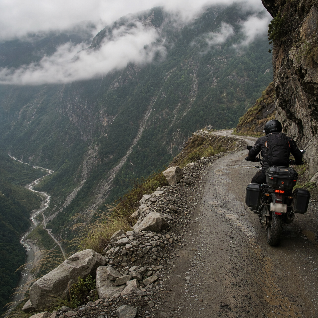
3. Karakoram Highway, Pakistan
The Karakoram Highway is one of the world’s great overland routes, but for motorcyclists it is dangerous in ways photos rarely capture. Built through active mountain geology, the route faces landslides, washouts, rockfall, glacial runoff, sharp elevation changes, and sections broken by reconstruction. Around Gilgit-Baltistan, spectacular scenery can distract from the constant need to scan for gravel fans, stray livestock, overtaking buses, and loose aggregate left by road crews. In wet conditions, runoff carries silt across corners, creating a surface that feels like wet cement dust under motorcycle tires.
Another major risk is remoteness. A mechanical issue or crash can leave a rider far from professional medical care, recovery transport, or reliable communication. Fuel quality and availability also vary by stretch, which matters on carbureted bikes or heavily loaded touring machines. The highway has improved significantly in many segments through Chinese and Pakistani infrastructure investment, yet improvement itself can raise risk because riders relax on smooth new pavement and then meet abrupt transitions to broken sections. Treat the Karakoram Highway as an expedition route, not a scenic cruise, and build delays into every day’s plan.
4. Skippers Canyon Road, New Zealand
Skippers Canyon Road near Queenstown is short compared with Himalayan or Andean routes, but it deserves inclusion because it compresses risk into a narrow, unforgiving space. Carved into rock during the gold rush era, the road features cliff exposure, minimal passing room, loose gravel, and sections where reversing to let another vehicle pass may be the only option. Rental car contracts often exclude it for good reason. On a motorcycle, the temptation is to focus on the stunning canyon views, yet the actual riding challenge is maintaining a calm line when the outer edge drops sharply away.
What makes Skippers Canyon especially deceptive is accessibility. Riders staying in Queenstown can reach it quickly and may underestimate it because it is close to a major tourist center. But tourism creates part of the danger. Visitors in unfamiliar vehicles misjudge width, stop in bad places for photos, or drift wide on gravel corners. For motorcyclists, this is a textbook route where slow is fast. Keep two fingers over the clutch, stay well inside your lane, assume every blind bend contains an oncoming vehicle, and avoid riding it in poor light when depth perception deteriorates.
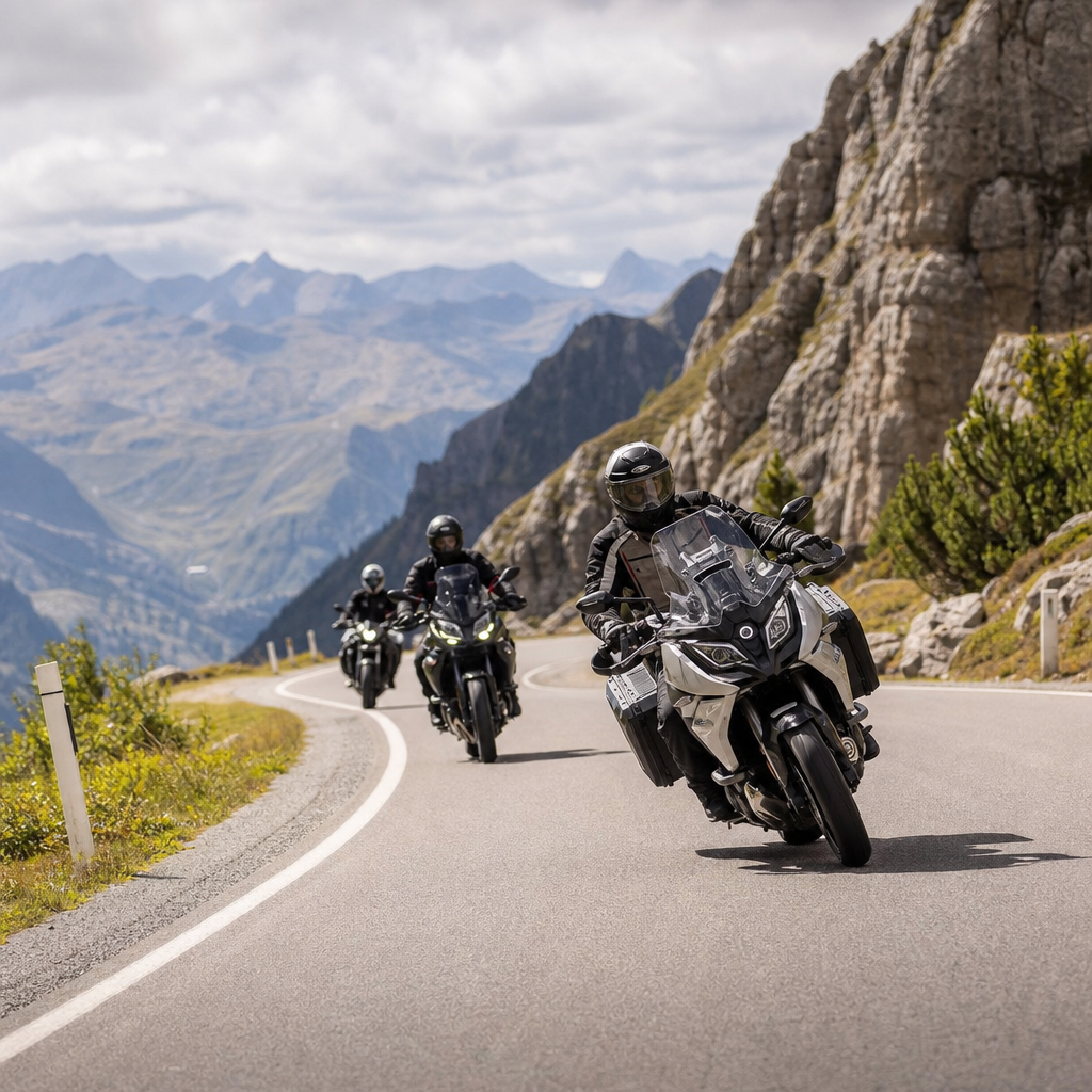
5. Stelvio Pass, Italy
Stelvio Pass is world famous, paved, and meticulously mapped, which leads some riders to think it is safer than it is. The danger comes from density and rhythm. Its stacked hairpins, steep gradients, changing weather, and heavy summer traffic create a technical environment where impatience causes crashes. Sport riders cross the centerline to straighten corners, cyclists descend unpredictably, camper vans cut into the opposite lane, and diesel residue from commercial vehicles can collect near apexes. Add rain, sleet, or lingering snowbanks, and a celebrated alpine ride becomes a low-speed but high-impact hazard zone.
The pass is manageable for experienced riders who respect conditions, but it punishes ego. I have seen riders fixate on a perfect uphill switchback cadence and then enter one corner too hot because a photographer, bus, or bicycle disrupted timing. The road also sits above 2,700 meters, where sudden cold affects tire temperature and rider dexterity. Early-season openings can leave debris from winter maintenance, while afternoon cloud can reduce visibility quickly. The safest approach is to ride Stelvio midweek, early in the day, in stable weather, with conservative corner entry and no pressure to “conquer” the climb.
6. Taroko Gorge Cross-Island Highway, Taiwan
Taiwan’s Central Cross-Island sections through Taroko Gorge are among the most visually stunning and operationally risky paved mountain roads in Asia. Marble cliffs, tunnels, blind corners, tour buses, scooters, and frequent rockfall warnings demand constant attention. Typhoons and earthquakes periodically damage the route, and even after repairs, temporary lane controls, uneven surfaces, and debris can persist. For motorcyclists, the biggest hazard is the transition from open scenic stretches to dim, damp tunnels with surface patches and changing traction. Visor contrast drops, hearing is distorted, and oncoming vehicles can appear suddenly at tunnel exits.
This road also illustrates why local weather intelligence matters more than a generic forecast. A blue-sky start in Hualien does not mean upper sections are safe. Mountain microclimates can produce runoff, fog, and fresh debris long after coastal conditions improve. Taiwan’s highway authorities issue closures and restrictions that riders should check the same morning, not the night before. If there has been seismic activity or recent heavy rain, postpone the ride. Scenic value never outweighs objective hazard on a route where the mountain routinely sheds material onto the carriageway.
7. Halsema Highway, Philippines
Halsema Highway on Luzon is one of Southeast Asia’s essential mountain routes and one of its most dangerous for motorcycles. It threads through the Cordillera Central, where fog, rain, landslides, steep grades, buses, trucks, and roadworks are common. Shoulder integrity is inconsistent, and some sections suffer from subsidence or broken pavement, especially after severe weather. The route is busy enough to be stressful yet remote enough that help may not be immediate. Riders who are comfortable on smooth twisties often struggle here because the challenge is not corner speed; it is constant adaptation to imperfect surfaces.
Commercial traffic is a major factor. Produce trucks and buses work hard on climbs and descents, sometimes crossing lane markings or leaving fluid on the roadway. In dense fog, their presence is felt before it is seen. That sensory delay is dangerous for riders who rely too heavily on vision and not enough on lane discipline and speed management. Plan Halsema Highway for daylight only, use auxiliary visibility if legal, and build in margin for weather holds. If locals say the mountain is closing in, believe them and wait.
8. D915 Bayburt–Of Road, Türkiye
The D915 in northeastern Türkiye is frequently cited among the world’s scariest roads because of its steep mountainside switchbacks, loose surfaces in places, and dramatic lack of barriers. The section descending from Soğanlı Pass has dozens of tight turns cut directly into the slope, resembling an oversized staircase laid onto a cliff. For motorcyclists, the challenge is managing exposure while dealing with uneven traction and occasional weather change rolling in from the Black Sea region. It is rideable in good conditions, but “rideable” should not be confused with forgiving.
What elevates the D915 from difficult to dangerous is its sparse traffic support. On busier tourist passes, another traveler may assist after a crash. Here, you can spend long stretches essentially alone. That matters if you puncture a tire, drop a loaded bike, or lose traction near an edge. Riders should bring repair capability, enough water, and a route plan shared with someone off the mountain. Attempt it only in dry weather and only if you are fully comfortable with steep, exposed hairpins on mixed surfaces.
9. Ruta Nacional 40, Argentina
Argentina’s Ruta 40 is not uniformly dangerous across its entire length, but several Patagonian and Andean sections are among the hardest long-distance motorcycle roads on earth. The threat is cumulative: relentless crosswinds, gravel detours, long fuel gaps, temperature swings, isolated stretches, and fatigue. In Patagonia, lateral wind can physically move a motorcycle across the lane, especially high-sided adventure bikes carrying luggage. Riders unfamiliar with sustained winds tend to overcorrect, tense their upper body, and exhaust themselves before the day is half done. That fatigue then magnifies every later decision.
Route 40 deserves a place on this list because it demonstrates how danger can come from endurance rather than a single cliff edge. A rider may handle one rough section well, then make a poor fuel, hydration, or campsite decision after eight draining hours. Mechanical sympathy also matters: chain wear, tire cuts, and loose fasteners become serious problems when towns are far apart. Use conservative daily distances, monitor weather windows carefully, and never pass fuel in remote Argentina because the next station may be closed, dry, or farther than expected.
10. Dalton Highway, Alaska, United States
The Dalton Highway is a benchmark extreme route for overland riders in North America. Running deep into Alaska toward the North Slope, it combines calcium chloride-treated gravel, heavy truck traffic, long distances between services, cold rain, wildlife, and fast-changing visibility. When dry, treated sections can be manageable. When wet, they become slick enough to challenge even experienced off-pavement riders. The highway’s industrial purpose matters here: truckers are working, not sightseeing, and their schedules, spray, and road position shape the riding environment. A rider who wanders mentally on the Dalton makes mistakes quickly.
The other major issue is consequence management. A simple fall can damage controls, lights, or luggage in a place where parts and shelter are not close by. Tires that looked acceptable in Fairbanks may be overwhelmed by sharp aggregate and loaded-bike weight. Satellite communication, spare layers, and disciplined fuel planning are not optional. In my experience, the smartest riders on the Dalton are the least dramatic ones. They slow for every truck plume, stop early when weather deteriorates, and treat reaching Deadhorse as secondary to getting back out safely.
How to use this route guide hub to plan safer rides
These ten roads are dangerous for different reasons, but the planning method is the same. Start with season and weather, then road surface, traffic type, fuel availability, communications, and medical access. Match the route to the bike, tires, load, and actual skill level you have today, not the version of yourself you imagine on social media. As this Route Guides hub expands, use it alongside our detailed country pages, packing checklists, and weather-window articles to build realistic itineraries. The payoff is simple: better route choices reduce crash risk more effectively than almost any accessory. Study the road, respect local conditions, and be willing to turn back when the mountain, desert, or weather says no.
Frequently Asked Questions
What makes a road truly dangerous for motorcyclists, beyond just sharp turns and dramatic scenery?
A road becomes genuinely dangerous for motorcyclists when multiple risk factors overlap and leave very little margin for error. Tight switchbacks and steep drop-offs are only part of the story. The roads most often ranked among the world’s most dangerous usually combine poor pavement quality, unpredictable weather, loose gravel, active rockfall zones, heavy truck traffic, blind corners, minimal guardrails, and long distances between medical or mechanical help. On a motorcycle, that combination matters far more than scenery or reputation.
Another major factor is consequence. A difficult road is not always a deadly road. Some routes are technically demanding but well maintained and well patrolled. The roads that earn a place on a danger list tend to punish even small mistakes. A minor misjudgment in braking, lane position, or speed can become a catastrophic crash when the shoulder is unstable, the drop is severe, or oncoming traffic regularly crosses the center line. For motorcyclists, especially those traveling internationally, the danger often comes from the environment around the road as much as the road itself.
Local traffic behavior also plays a huge role. In many high-risk corridors, riders must share space with overloaded buses, aggressive passing trucks, livestock, pedestrians, and drivers who treat lane markings as optional. Add fog, altitude, fatigue, and delayed emergency response, and a road can quickly shift from challenging to life-threatening. That is why the most dangerous roads in the world for motorcyclists are not simply adventurous routes. They are roads where design flaws, exposure, traffic patterns, and limited rescue options combine into a high-consequence riding environment.
Are the most dangerous motorcycle roads always in remote mountain regions?
No. Mountain roads dominate many danger rankings because they naturally concentrate risk: steep gradients, unstable slopes, hairpin turns, changing weather, and limited runoff space. However, not every dangerous road is a remote alpine or high-altitude pass. Some of the most hazardous roads for motorcyclists are lower-elevation highways with chaotic traffic, poor surface maintenance, weak road engineering, frequent flooding, or extremely inconsistent driver behavior.
What matters most is the risk profile, not the postcard image. A heavily used freight route with broken pavement, no lighting, worn lane markings, and aggressive overtaking can be just as dangerous as a cliff-edge mountain pass. In some regions, tropical roads become deadly because of rain-slick bitumen, hidden potholes, washouts, and reduced visibility. In others, desert routes create danger through heat stress, crosswinds, isolation, and long stretches with no services. Urban-adjacent roads can also be high risk if motorcycles are forced to mix with dense bus and truck traffic in poorly controlled corridors.
For motorcyclists planning international rides in 2026, the key lesson is to evaluate roads by conditions, not reputation alone. A famous mountain road may be seasonally manageable with the right timing and preparation, while a less glamorous regional highway may be consistently more dangerous because of infrastructure failure and traffic conflict. The smartest riders look at surface condition, weather exposure, traffic composition, elevation, emergency access, and local crash patterns before deciding whether a route is worth attempting.
How should riders prepare before attempting one of the world’s most dangerous roads?
Preparation starts well before the bike moves. Riders should research current road status, not just old travel stories or social media clips. Conditions can change dramatically from one season to the next due to landslides, construction damage, political disruptions, flooding, snow, or pavement collapse. It is essential to check local advisories, regional weather forecasts, fuel availability, daylight hours, and whether sections of the road are currently restricted or degraded. For international riders, understanding local riding norms and emergency numbers is just as important as studying the route map.
The motorcycle itself must be suited to the road. Tires should have enough tread for wet, broken, or mixed surfaces, and brakes, suspension, chain, battery, and lights should be inspected carefully. If the route includes altitude, extreme cold, or remote sections, riders should carry puncture repair tools, basic spares, water, a first-aid kit, thermal layers, offline navigation, and some way to communicate when cell coverage disappears. On roads where surface failures or unpaved sections are common, luggage should be secured tightly and overall bike weight kept manageable.
Just as important is honest self-assessment. Some roads demand advanced braking technique, slow-speed balance, downhill corner control, and the ability to read changing traction in real time. Riders should not let bucket-list pressure override skill level, fatigue, or weather judgment. If visibility is collapsing, if local drivers are becoming unpredictable, or if the road surface is worse than expected, turning around is often the most professional decision a rider can make. On the world’s most dangerous roads, preparation is not about bravado. It is about increasing the margin for survival.
What are the biggest mistakes motorcyclists make on high-risk roads?
The most common mistake is treating a dangerous road like a sightseeing route instead of a dynamic hazard zone. Riders often become distracted by scenery, overconfident after a few successful corners, or tempted to ride faster because the road appears empty. On many notorious roads, danger does not arrive as a constant challenge. It appears suddenly: a bus in your lane, diesel in a blind bend, gravel washed across the apex, a missing section of pavement, or dense fog that cuts visibility to a few bike lengths. Riders who assume the next corner will resemble the last one often get caught out.
Another major mistake is mismanaging speed and fatigue. Long descents, altitude, vibration, weather stress, and constant concentration wear riders down quickly. As fatigue builds, braking points creep later, hazard perception slows, and small technical errors multiply. Many crashes on dangerous roads happen late in the day when a rider pushes on to “finish the route” instead of stopping early. The same is true in rain or low light. Continuing because a destination is close can be far riskier than waiting for better conditions.
Group-riding behavior is another problem. Riders may follow the pace of a stronger rider, target-fixate on the bike ahead, or feel pressure not to stop when conditions deteriorate. On high-consequence roads, every rider needs room to choose lines, react to debris, and brake independently. A final mistake is underestimating local traffic patterns. Trucks cutting corners, minibuses overtaking blindly, animals entering the roadway, and unofficial road repairs are common on many of the world’s most dangerous routes. Safe riding in these places depends on humility, spacing, patience, and constant expectation that something unexpected is about to happen.
Should most riders avoid these roads entirely, or can they be ridden safely with the right strategy?
That depends on the specific road, the season, the rider’s experience, and current conditions. Some dangerous roads can be approached with a disciplined risk-management strategy and become challenging but manageable for skilled, well-prepared riders. Others are simply poor choices for most motorcyclists at certain times of year because the hazards become too concentrated. Snowmelt, monsoon damage, rockfall season, flood periods, or nighttime freight traffic can transform a marginally acceptable road into one where the consequences outweigh the reward.
Safe passage, when it is realistic, usually comes down to timing and restraint. Riding in daylight, avoiding peak truck hours, choosing the dry season, building in extra time, and monitoring weather closely all reduce exposure. So does refusing to ride when visibility collapses or the surface starts failing under changing conditions. Riders with strong roadcraft skills can lower risk by keeping speeds conservative, maximizing sight lines, using disciplined corner entry, and treating every blind section as occupied. Even then, “safer” does not mean safe in an absolute sense. These roads remain high-consequence environments.
For many riders, the wisest decision is selective avoidance. There is nothing unadventurous about skipping a route with active landslides, unreliable emergency access, or a current pattern of serious crashes. The best motorcycle travel planning is not about checking off famous names. It is about matching the route to your skill, machine, support options, and tolerance for risk. In a 2026 route guide, the purpose of identifying the world’s most dangerous roads is not to glorify danger. It is to help riders make informed decisions before commitment turns into exposure.